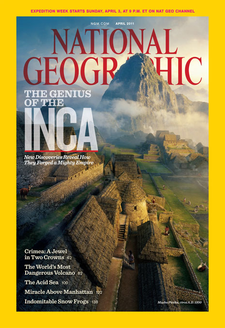
FAYETTEVILLE, Ark. – Researchers at the Center for Advanced Spatial Technologies at the University of Arkansas helped an artist recreate the culture of Machu Picchu for the cover story in the April issue of National Geographic magazine.
In 2005 and 2009 University of Arkansas researchers visited Machu Picchu with high-resolution laser scanning instruments and created the first comprehensive high-resolution 3D data set for this wonder of the world. These data served as a key resource on the topography, landscape and existing structures for freelance artist Dylan Cole as he created the cover art. In addition to the cover art, the CAST team also created a video of the site for the iPad version of the magazine.
National Geographic magazine sent Amanda Hobbs, an art research editor, to Cuzco and Machu Picchu to visit the project in 2009 as part of her research for graphics for the upcoming articles.
“In the beginning, we weren't planning on creating an illustration of Machu Picchu, but when we realized what an incredible resource CAST had developed, we started thinking about how we could incorporate it into our coverage,” said National Geographic creative director Bill Marr. Marr came up with the idea of a cover illustration, and Hobbs put Cole in touch with CAST researchers Snow Winters, Angie Payne and Katie Simon who then assisted Cole in accessing the data.
Once the cover art was completed, the editor of the iPad edition of National Geographic contacted Winters and Payne to create a video of the site based on the data. In the video the magazine cover dissolves into a 3D fly-over of the site. Winters and Payne used the 3D laser data, information from Google Earth and a Google Earth 3D model of the architecture at the site that was previously created by Peter Olsen. In 2010 Olsen discovered the CAST 3D data and used it to build a SketchUp architectural model that was placed in the Google 3D Warehouse. From there it was chosen by Google to be included in the 3D layer for Google Earth, which allows anyone with access to Google Earth to virtually visit Machu Picchu.
CAST researcher Payne first visited the site in 2005 along with Alexei Vranich of UCLA as part of a National Science Foundation-funded research project organized in cooperation with the Peruvian Instituto Nacional de Cultura, which manages the site. Payne used an Optech laser scanner, a device that sweeps a narrow laser beam across distant surfaces and uses the time it takes for the light to reflect back to the instrument to make precise measurements. The scanner acquires 3D measurements that are precise to within a few millimeters over a half of a kilometer.
“We were fortunate to have an extraordinarily long-range instrument that could cover this huge site” said Payne, “and the mountains around the site presented perfect locations to set up the device.” Payne created an initial detailed 3D model of the site in 2005 that included some 80 million data points at a resolution of 3 centimeters.
In 2009, 20 UCLA and other college students participated in a field school along with CAST researchers Winters, Simon, Malcolm Williamson and Adam Barnes lead by CAST’s director Jack Cothren and University Professor Fred Limp.
In both 2005 and 2009 scanning activities had to be conducted at night. More than 500,000 visitors travel to Machu Picchu each year and it is impossible to record the necessary data among such large crowds. As a result scanning began when the site was closed to visitors at 4:30 p.m. and continued into the night.
“Being at Machu Picchu at night was an amazing experience,” said Williamson. “Stellar arrangements and, in particular the Milky Way, played a key role in Incan cosmology and at night on Machu Picchu the stars are truly spectacular.”
Once the data were acquired, Winters and Payne processed the data and it is now publicly available, along with computer software to manipulate the data and perform measurements on the CAST website.
“We felt it was important to make these data available to scholars and the public,” said Limp.
Contacts
Jackson Cothren , director, Center for Advanced Spatial Technologies
J. William Fulbright College of Arts and Sciences
479-575-6790,
Melissa Blouin, director of science and research communication
University Relations
479-575-3033,